Kulinarische Radtour 1: Altmünster - Gmunden - Hoisn


- All weather
- Suitable for families
- culinary interesting
Interactive elevation profile
Create PDF
Tour-Details
18 km
Metres in altitude: 61 m
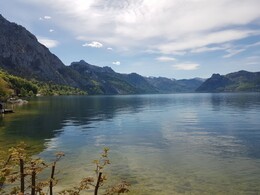
From Altmünster town hall, we cycle left down Marktstraße to the subway to the lakeside promenade, keep left and cycle past the campsite. Then we have to cycle back up to the B145 and turn right onto the cycle path to Gmunden. After passing the outdoor swimming pools in Altmünster and Gmunden, we reach Toscanapark. Here you should make a detour to the Seehotel Schloss Ort. Ort Castle (also spelt Orth until the early 20th century) is a complex of two castles on Lake Traunsee and is located on the island of Ort in the town of Gmunden in Upper Austria. It consists of the better-known Seeschloss on an island in Lake Traunsee and the Landschloss connected via the bridge. The lake castle is one of the oldest buildings in the Salzkammergut. (Source: Wikipedia).
We now continue along the lakeside promenade into the pedestrianised area of Gmunden to the town hall square, where the boat landing stage is located. From here we continue to the Traunbrücke bridge, which we cross. Immediately after the bridge, we take a sharp right onto Schiffslände and then continue until we reach Traunsteinstraße. There we turn right and follow the road. We leave the valley station of the Grünberg cable car on the left and soon reach the Landhotel Grünberg .
If we follow the Traunsteinstraße for approx. 2 km, we reach the Feriengasthof Ramsau and shortly before the so-called Umkehrplatz, the Seegasthof Hois'n Wirt. If you don't want to cycle back the way you came, you can take the boat to Altmünster, as the inn has a landing stage. However, you should enquire about departure times and bicycle transport beforehand. (This cannot be guaranteed for reasons of space € 4 per bike (bike groups must register)
This is a short but beautiful cycle tour that takes you to 3 inns offering many local specialities.
A little story should not go unmentioned in this context. In earlier times there were many originals, which are unfortunately becoming fewer and fewer these days. One such original was the so-called "Buckelklopfer" at the Hois'n.
Whether you get the "Schlag" or not is of secondary importance. In any case, you get good Upper Austrian hospitality and a hearty "Jaus'n".
You have now reached the end of the tour, but you should continue a few metres further to the "Unterm Stein" turnaround point. There, a forest path leads up to the Moar Alm on the left, which you follow for approx. 100 metres. Then turn left towards Karbachwildnis and you will come to a striking rock, the memorial stone for the Traunstein victims. The ascent to the 1691 metre high Traunstein is one of the most magnificent mountain tours in Upper Austria, but is far too often underestimated, which unfortunately results in fatal accidents every year. The first entry in the memorial book dates back to 1899, when the first victim was mourned.
Every year at the start of the climbing season, a mass is held at the memorial stone.
Return to Altmünster in the opposite direction. You can stroll around Gmunden or stop for a bite to eat on the town hall square and the esplanade. There are a variety of options here. One speciality is the Cafe Grellinger, a gem right by the tram stop on Franz-Josef-Platz. In addition to the many specialities that the café has to offer, the interior alone is worth a visit. You feel like you've been transported back to the Gründerzeit. It is no coincidence that the café was also one of the filming locations for the TV series "Schlosshotel Orth". However, there is not much space in the café. Patience is the order of the day here. But it's definitely worth the wait.
- All weather
- Suitable for teenagers
- Suitable for seniors
- Suitable for single travelers
- Suitable for friends
- Suitable for couples
- Spring
- Summer
- Autumn
Please get in touch for more information.
Marktstraße 6
4810 Gmunden
Phone +43 7612 87181
E-Mail info@traunsee-almtal.at
Web www.traunsee-almtal.at/altmuenster
Vis-à-vis users
1. The tours presented for hiking, walking, biking and road biking, mountain biking, motorbiking, horseback riding, climbing, cross-country skiing, and going on skiing and snowshoe tours etc. are to be considered non-paid tour recommendations and only serve as non-binding information. We have no intention of concluding a contract with the users of this website. The utilisation of the data does not lead to the establishment of a contract with us.
The data may only be used for private use; any commercial use is prohibited. In particular, it is not permissible to offer the data on commercially run websites, file-sharing platforms etc. or to use it to develop commercial products. Downloading data does not imply that users are granted rights to the data concerned.
The tour recommendations posted were created with utmost care; nevertheless, we assume no liability for the correctness and completeness of the information.
We point out that neither the tour recommendations included on this website nor the associated data and information were posted by us, but rather by third parties (Art. 16 Austrian E-Commerce Act). We have no influence on whether the details provided (e.g. distance, level of difficulty, change in altitude, description etc.) are authentic, correct and complete. We do not review these third-party contents. For this reason, we assume no liability for the authenticity, correctness and completeness of the information.
Construction-related measures or other influences (e.g. landslides and similar occurrences) can lead to temporary or permanent changes in a route (e.g. loss of a bridge and similar occurrences). Such occurrences can lead to part of the route or the entire route becoming impassable.
The use of the data as well as undertaking (riding, walking, taking etc.) the recommended tours or using the network of paths occurs at users’ own risk and on their authority. In particular, users themselves are responsible for the choice of route, outdoor orientation, adherence to traffic rules, supplies and equipment for tours listed in Point 1 (e.g. bicycle etc.), wearing a helmet, estimating their own fitness, recognising dangers and maintaining an appropriate velocity. We exclude ourselves from any liability whatsoever for damages, in particular accidents, that occur whilst taking part in the recommended tours.
2.Some of the tours lead over roads with normal traffic conditions. Please observe that there is an increased risk which can be avoided by means of appropriate attention and proper estimation and implementation of one’s own abilities. For this reason, please travel a route that is unfamiliar to you slowly and with special care. Pay constant attention to potential dangers and always observe traffic. Do not leave the routes featured in descriptions.
The potential use of private roads, in particular forestry roads and agricultural transport roads, can be subject to legal restrictions, which must be observed and adhered to.
The normal traffic rules apply. Each user (e.g. biker, motorbiker) is responsible for adhering to these rules and maintaining his/her bike/vehicle and its equipment (lights, brakes etc.) in good working order. Each user is also responsible for ensuring that he/she rides at a velocity that is appropriate for the conditions and his/her skill level and for maintaining sufficient distance to the rider in front. We explicitly recommend adjusting velocity to correspond to the respective field of vision, wearing a helmet, using reflective clothing (or similar) and employing bicycle lights in line with regulations.
3.Each tour requires good physical fitness as well as detailed planning. We explicitly recommend only taking the tours in the case of optimal healthiness.
We recommend that you conclude an accident and liability insurance policy. Use an onboard computer that displays the respective kilometres travelled per day and is calibrated for the front wheel.
4.Special for mountain bikers – Fair-play rules:
Mountain biking is one of the most wonderful outdoor leisure-time activities. Whilst biking or on a mountain biking tour, mountains and lakes, meadows and cabins are re-discovered in new ways. A couple of rules for fair play in the forest help to avoid conflicts whilst mountain biking.
a.Pedestrians have the right of way: We are accommodating and friendly to pedestrians and hikers. Upon encountering these fellow travellers, we alert them by using the bicycle bell and slowly overtake them. We avoid paths with heavy pedestrian traffic altogether. Take nature into account: We do not leave refuse behind.
b.The braking distance should be half of the total distance visible: We ride at a controlled pace, are ready to brake and maintain a braking distance half as long as the total distance visible, especially in curves, because we always have to count on obstacles on the path. Damage to the path, stones, branches, wood piles, grazing livestock, cattle grids, barriers, tractor-type forestry machines and authorised vehicles pose dangers that we need to be ready for.
c.Don’t drink and drive!: Do not drink alcohol when mountain biking. Take care at stop-off points (dealing with bike racks, dirty shoes or clothing).
It is obligatory to provide first aid!
d.Marked routes, closed paths and blockades: Keep to the marked routes, observe the blockades and accept that these roads are primarily for agricultural and forestry use!
Blockades can often not be avoided and are in your own interest. Biking beyond the intended path and outside of opening times is punishable and turns us into illegal bikers.
e.We are guests in the forest and behave accordingly, including vis-à-vis forestry and hunting staff. Whilst mountain biking, mobile telephones and music players are forbidden! Biking requires your full attention.
f.Avoid unnecessary noise. Out of consideration to the animals living in the wild, we only bike during full daylight. As a principle, we always wear our helmet (even when riding uphill)! Don’t forget emergency supplies: We always have a repair set and bandages along.
g.Don’t overestimate your skills: We should not overdo it when it comes to biking technique and physical fitness. Take the level of difficulty posed by the route into consideration and make a precise estimate of your experience and skills as a biker (braking, bell, lights)!
h.Close gates: We approach grazing livestock at a walking pace and close every gate behind us. We should avoid causing escape and panic reactions in the animals. Nothing stands in the way of the fun and athletic challenge in the mountains and forests!
i.Traffic rules: The general traffic rules (StVO) apply for all the mountain biking routes and we adhere to them. Our bike therefore needs to be in perfect technical condition and equipped in line with the traffic rules, including brakes, a bell and lights. We inspect and service our mountain bikes regularly anyway.
5.We assume no liability for the contents of external websites; in particular, we assume no liability for their statements and contents. Moreover, we have no influence on the design or contents of the websites to which hyperlinks on www.salzkammergutshuttle.at lead or from which hyperlinks lead to www.salzkammergutshuttle.at. There is no on-going review of websites to which hyperlinks on www.salzkammergutshuttle.at lead or from which hyperlinks lead to www.salzkammergutshuttle.at. We do not appropriate the contents of websites to which hyperlinks on www.salzkammergutshuttle.at lead or from which hyperlinks lead to www.salzkammergutshuttle.at.
Vis-à-vis bloggers
PLEASE OBSERVE:
1. Each of your tour recommendations for hiking, walking, biking and road biking, mountain biking, motorbiking, horseback riding, climbing, cross-country skiing, and going on skiing and snowshoe tours etc., along with other details and information, is free of charge. In particular regarding the correctness of the information, we assume no liability, nor do we assume any liability whatsoever for the consequences of the use of your tour recommendation by a third party (in particular by a user of this website). We do not review the tour recommendations you post, including other details and information, at any time.
We have no intention of concluding a contract with persons who post tour recommendations and/or other details and information on this website. Posting data (information) does not imply that a contract has been concluded.
By recommending a tour, we assume special responsibility vis-à-vis other athletes. Please take this responsibility seriously and describe your tour recommendation with utmost care and to the best of your knowledge and belief.
2.Your tour recommendations must therefore clearly and unambiguously include at least the following criteria and provide a sufficiently detailed description:
• Starting point
• Detailed route description
• Distance/Overall distance
• Level of difficulty
• Dangerous spots
• Average duration of trip
• Change in altitude
• Finishing point.
If possible, please provide the change in altitude.
3.When you post a tour recommendation, you give us the order to save your tour recommendation and/or the details you provide on our website and to make it/them accessible to third parties, in particular to users of this website, in the long term. We reserve the right to block or delete tour recommendations and/or other details and/or information that you post, either partially or entirely, at any time without providing a justification. Should this occur, it grants you no rights whatsoever.
Thank you for your efforts!
4. We are not responsible for the contents of external websites; in particular, we do not assume any liability for their statements or contents. Furthermore, we do not influence the design or contents of websites that can be accessed from www.salzkammergutshuttle.at via hyperlinks or that use hyperlinks to refer to www.salzkammergutshuttle.at. The websites that can be accessed from www.salzkammergutshuttle.at via hyperlinks or that use hyperlinks to refer to www.salzkammergutshuttle.at are not regularly monitored. Furthermore, we do not assume any claims to the websites that can be accessed from www.salzkammergutshuttle.at via hyperlinks or that use hyperlinks to refer to www.salzkammergutshuttle.at.
Interactive elevation profile
Create PDF
Tour-Details
Suggest changes
Please let us know how we can improve the quality of this property or if there is any incorrect information on this page (eg. opening hours, contact, etc.).
Please fill in all fields marked *.